Ama Dablam | An Alpkit Long Read
Deciding to climb a peak in the Himalayas for the first time wasn’t quite a 2020 New Year’s resolution, but it was about as close as I normally come to making one. I needed something to aim for, some purpose or goal to motivate me both physically and mentally. Little did I know there was a global pandemic around the corner that would turn our world upside down and test us all in ways we didn’t expect.
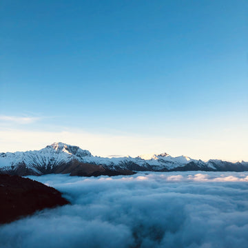
In January 2020, I set my sights on climbing Ama Dablam (6812m) after speaking to a few friends who had done it and figuring it was a mountain that would satisfy my desire to try more technical climbing at high altitude. Not to mention it’s an amazing looking mountain that looks impossible but actually isn’t! It sits above Pangboche, in the Khumbu valley of Nepal, and is one of the most striking peaks visible on the trek to Everest base camp. I would go so far as to say it upstages Everest, but then I might be biased. Hard to argue with this view though:

Everest & Lhotse in the distance & Ama Dablam on the right.
Of course, 2020 didn’t go to plan by anyone’s standards. During the first lockdown, I trained at home doing laps of the stairs (293 flights was the equivalent of climbing Scafell Pike!) and built a climbing wall on the outside of the house to keep my strength and sanity. In September, I made the decision not to travel to Nepal that autumn and postponed my plans for another year. Thanks to the vaccination programme, lots of testing, and a fortuitous bit of timing, I was finally able to go in November 2021.
Flying into Lukla from Kathmandu was a long anticipated experience, with the infamous short runway that ends abruptly in a mountain wall at one end and a cliff at the other. The landing is over before you know it as the runway is so short and steep the plane barely has time to apply the brakes before it reaches a standstill by the single-room ‘terminal’. Lukla is at 2860m and Ama Dablam base camp is at 4650m, so we spent the next 5 days trekking the 16 miles at a gentle pace to allow us time to acclimatise.
We followed the same trail as the approach to Everest Basecamp, through places that I’d only ever read about, like the town of Namche Bazar nestled in a compact amphitheatre, and the Tengboche monastery perched on an exposed hilltop. There wasn’t much evidence of the destruction caused by the earthquake that hit the region in 2015; it seems all the stupas (like the one below) and buildings had been repaired or completely re-built. The trail was very quiet compared to a normal year (we saw only a handful of other groups), and the tea houses we stayed at were very grateful for our business as it has been a tough few years for an area so reliant on tourism. I felt very privileged to be there.

Prayer wheels and a stupa in Kunde, Khumbu valley.
On the approach, we caught glimpses of Everest and Lhotse from time to time; it’s incredible to think that they are another 2000m higher than Ama Dablam, which itself is 2000m higher than Mont Blanc. Once Ama Dablam came into view, it was hard to take my eyes and mind off it. The profile of the mountain is like two wings extending from a flat topped summit, and the final section looks impossibly steep. Over the days it gradually got bigger as we got closer, but never looked any less intimidating.

Ama Dablam from one of the many suspension bridges crossing the river.
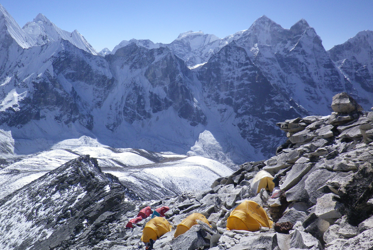
Our basecamp was at 4620m in a beautiful grassy meadow, with a stunning panorama of mountains which changed shade and colour under both sun and moonlight. The nights were so clear we could see what seemed like a gajillion stars and at least two planets, and some nights the moonlight was so bright you didn’t need a head torch to find your tent.

The view from basecamp never got old.
We spent the next week acclimatising and moving gear up the hill in stages to allow our bodies time to adjust to the reduced oxygen available. The first time we carried packs with food and summit clothing up to Advance Base Camp (ABC) at 5420m, it took 3hrs 40mins and felt like wading through glue. I couldn’t believe how breathless I was at such a slow pace. Even the flat sections were hard work! On the first trip, we just dropped loads at ABC and walked back down to base camp.
After our Puja ceremony (performed by the Lama from the nearest village), we headed back up with even heavier packs with more food and overnight gear for higher up the mountain. This time we stayed the night at ABC and the next day took loads up to Camp 1 (5800m) for the first time. The route from ABC to C1 has an awkward ankle-snapping boulder field (the kind where despite cairns to mark the route, you never go the same way twice) and then rock slabs with fixed ropes. The slabs reminded me a bit of Idwal Slabs in the Ogwen Valley: never hard but you’d go a long way if you slipped, so clipping into the fixed lines was comforting. With big bags and in boots, it soon had me huffing and puffing with effort, but it was a darn sight more fun than the boulder field.

Camp 1, looking down towards ABC.
After a short rest at Camp 1, we descended back to ABC and stayed another night, and while I had no trouble sleeping, my appetite was definitely suffering. I tried to eat a packet of couscous I would normally finish in one sitting at home, but couldn’t get it all down for dinner, so ended up eating it for breakfast and lunch the following day! We went back up to Camp 1 with another load, which felt easier than the day before despite a little light snow, and this time stayed the night. At 5400m this was higher than I’d ever been before, and I didn’t sleep all that well, waking with a headache despite drinking loads. In the morning it was snowing, so we headed back down to basecamp, this time abseiling back down the slabs from Camp 1 as they were covered in a slippery blanket of snow. I began to really hate the boulder field…
Back at basecamp, we spent a few days waiting for a suitable weather window and making the most of our Sherpa team’s excellent cooking skills by filling up on food. We played *a lot* of cards, and lost innumerable games of Connect Four to Tim (the expedition organiser) who also imparted as much advice as he could to help us prepare for what lay ahead.
Finally the time had come to leave for the summit push, with a plan to spend 4 nights and 5 days on the mountain in order to reach the top when the winds were at their lowest. I kept thinking to myself “Just 5 more days of solid effort and it’ll all be over”. This time we skipped ABC and went all the way to Camp 1 on the first day, which took just over 5 hours. The lower section felt easier than it had before, but it got colder and windier higher up so by the time I got to the top of the slabs I was very glad to dive into a tent and get a brew on. We had a rest day the next day (to make sure we were fully acclimatised) and just went along the ropes a little way towards Camp 2, to get an idea of the route and terrain ahead.

A view of the upper mountain taken a couple of hours walk above base camp.
The following day, we left with heavy packs filled with our overnight gear, food, and summit clothing, plus we were wearing our double boots for the first time which made everything feel so much harder. The route from Camp 1 to 2 is mostly horizontal scrambling/easy climbing with a few steeper sections, which would be quite enjoyable with a lighter pack and boots (if only!). I took every opportunity to sit and take the pack weight off my shoulders, even if only for a few seconds. The final vertical section before Camp 2 is called the Yellow Tower, and is around 20m of HVS climbing (if it were at sea level). At nearly 6000m though, grades mean nothing and style goes out of the window. Even with two jumars plus feet on the rock and a haul system set up by the Sherpas to bring up our packs, it was bloody hard work.
After about 5 hours, we made it to Camp 2; a collection of tents haphazardly pitched on and around the rock tower at 6000m. It is the most exposed and ridiculous place to spend a night, but there is literally nowhere else it could be positioned. You basically unclip from the fixed lines to get into your tent, and any calls of nature are answered within a foot of where you sleep! The snow and rocks in our porch were so loosely packed that we could see through the ‘floor’ straight down to the valley floor about 2000m below. Not for the first time I thought “It’s a good thing my Dad can’t see this view”. Luckily I didn’t inherit his vertigo!

Photo Credit: Curtis Stock
The infamous Camp 2 (our tents were behind the far rock tower)
Having arrived at Camp 2 early afternoon, my tent mate and I set about trying to get comfortable (stuffing clothes under sleeping mats to try and level out the slope of the floor) and melting snow for water. I boiled pan after pan of water to fill our bottles, then ate a boil-in-the-bag sticky toffee pudding to keep the calories up, before lying down about 5.30pm to try and get some rest. At 9.30pm, the alarm went off and I started melting more snow to heat our dinner and top up our water bottles. We tried to do as much as possible from inside our sleeping bags (as it was -18°C) until the point where we had to get out of them to put on our summit clothing. For me, that was 4 layers top and bottom, which takes longer than you might think to get into! In my pack, I had a super warm down jacket, warmer gloves and mitts, and some water and snacks.
We left at 11.15pm, clipped a jumar plus safety into the fixed lines and spent the next 3 hours or so climbing the section known as the Grey Couloir. This was fairly steep mixed rock, ice, and snow (perhaps around Scottish Grade III), which again would have been great fun climbing had it been closer to sea level. Unfortunately, I hadn’t tightened one of my boots enough, so it felt harder than it should have a lot of the time. Thankfully the fixed lines and jumar meant I could rest as much as I needed and didn’t have to move at the same pace as Pinju (our leading climbing Sherpa), whose headlamp was always ahead of me. After what felt like forever, the angle eased and we started traversing what is known as the Mushroom Ridge, which is undulating snow and rock that weaves from one side of the ridge to the other, with big drops on both sides. The left side of the ridge was exposed to the wind, which, although only about 20mph, brought the temperature with windchill down to around -30°C. I remember thinking “Oh no, wind!” and hoping it wouldn’t get any stronger as we went higher, as it was worryingly cold and I was already struggling with intermittent feeling in my hands and feet.

Chris near the top of the Grey Couloir in the early hours of summit day
Towards the end of Mushroom Ridge, I turned to Chris (our western leader) and asked how far back the others were. Although we’d staggered our departure times from Camp 2, to start with I could see the torchlights of at least 4 others close behind us in the Grey Couloir. When Chris replied that they’d all turned back, I was surprised as I considered myself the least fit and experienced of the whole group! I felt ok though, I knew I had plenty more gas in the tank and more layers I could put on, so for me there was no question of turning round.
At the end of Mushroom Ridge, Chris and I stopped briefly at Camp 3 (which rarely gets used overnight as it is so high and exposed; the wind had ripped off all the tent doors) and had a quick snack and drink after around 6 hours on the move. Pinju had gone back a little way to get a spare rope from one of the other Sherpas, again demonstrating just how incredibly fast and fit they are. It was still dark, and soon we were moving up steep snow slopes at around 6400m. At that point I started getting cold, so I swapped my gloves for mitts and added my down jacket on top; I was anxious for the sun to come up to get a bit more warmth. With the steepness of the slope and the altitude, I was moving too slowly to really get the blood flow going, so I had to stop and wiggle my toes periodically to try to stop my feet from going completely numb. It was hard work, but I knew I had it in me to keep going, I just had to keep putting one foot in front of the other.
At around 5.30am, the dawn started pinking up the skyline, and I paused to take it all in as I knew my camera would never capture the magic quite the way my eyes could. Eventually I found myself on the steep summit slopes, which seemed to go on forever, and I finally stepped onto the broad, flat top of Ama Dablam at 9.15am.

Chris and Ronnie on the summit of Ama Dablam (6812m), with Everest in the background.
The ubiquitous prayer flags marked the highest point (either 6812m or 6856m depending on which map you look at!), and Pinju, Chris, and I had the place to ourselves. Looking across at Everest and the hundreds of other peaks both higher and lower than where I stood was an incredible moment that I’ll never take for granted.
Of course, getting to the summit was only halfway and I think it’s fair to say I came close to my physical limit on the descent. After an 18 hour summit day, we got back to Camp 2 at 5pm. It was actually the next day on the ropes back to Camp 1 when I hit the wall, having not eaten a proper meal in more than 24 hours. I would not have made it up and down safely without the help of Pinju and Chris, so I owe them both a huge thank you. It was without a doubt the hardest thing I have ever done.

Pinju on the descent of Mushroom Ridge

On the summit of Ama Dablam, looking at Nuptse, Everest & Lhotse.
A few people have asked what I did to prepare for climbing Ama Dablam, and the short answer is ‘quite a lot’. It took 18 months of consistent effort, and I still felt like I could have done more. I focussed my preparation on the things I could control (physical and mental training, clothing and equipment), and tried not to worry about the aspects outside of my control. Factors like the pandemic, the weather, route conditions, and other people were things I could not affect, so I just accepted I had to adapt to whatever fate might throw at me.
I have about 20 years of mountaineering experience on snow, rock, and ice in the UK and in the Alps and Andes. After speaking with friends (both very fit and competent climbers) who had been on Ama Dablam, I got the impression that experience alone wouldn’t be enough to get me to the summit. One described it as “f***ing hard” and knowing she’d been on Denali, I took that as a fair warning!
I’ve never been any good at sticking to a training plan. Preparing for previous trips has usually involved me attempting to go for a few runs, realising how much I hate it, and giving up in favour of just going climbing whenever I could (i.e. never enough). This time I did my homework. Having read ‘Training for the New Alpinism’ by House & Johnston (highly recommended), I bit the bullet and bought a 6-month training plan from Uphill Athlete and downloaded the TrainingPeaks app. This mapped out a structured training program, including strength and cardio training, and most importantly helped me log and monitor my progress. Seeing each workout turn green, amber, or red depending on how much I’d done worked like a dream for my motivation - nothing like a bit of gamification! As a result, I did 326 hours of training, covering 480km and over 20,000m of ascent in 2021 (and half as much in 2020).

Some training days were more fun than others! (Not shown, laps of Win Hill in the pouring rain).
I also used another book (‘Roar’ by Stacy Sims) focussed specifically on female physiology to help adapt my training to be most effective for me, rather than just following advice designed for men. Understanding the need to eat differently to support my training was a key point, and even with a background in Sports Science, there was so much I didn’t know. For example, upping my protein intake and timing it properly so I got the most benefit from it, and managing my hydration on long hill days meant I recovered quicker and was able to train 6 days a week without getting injured.
It wasn’t just physical fitness that I needed though. I knew I would need to be mentally prepared for the difficulty of the climbing, and that the length of the effort required and discomfort along the way would require a certain resilience. This is something that is often overlooked, and I honestly think success on summit day is 50% mental and 50% physical. Your mind is what tells your body to move; if your mind gives up before your body, it doesn’t matter how fit you are, you won’t make it. I listened to a lot of podcasts about mental training, and made notes whenever I heard something that really resonated with me so that I could refer back to them when I needed to. I also made myself some mood-lifting playlists that helped get me through hard training sessions, and tough days on the trip itself.
I spent a lot of time working out my clothing and equipment systems for the trip. Naturally I have an unfair advantage in this respect as it is literally my job. In my own time, I made a pair of down-filled ¾ length trousers and designed a prototype box wall down jacket for summit day. The greater part of my clothing system were tried and tested layers I’ve used on every trip from the UK to the Alps in all sorts of conditions. Some of my go-to pieces were my Kepler Zip Neck merino baselayer, Griffon hoody, Morphosis jacket, Katabatic jacket, and Ardent softshell trousers. I’m not ashamed to say I wore the same Griffon hoody for 2 weeks solid, from basecamp to the summit, back down, and out to dinner in Kathmandu on the way home!

Packing jenga - how to get all this into two kit bags and under 30kg!
In terms of equipment, I wouldn’t have been without my Juice Boost power bank, Flare solar panel and Lampray lantern at basecamp (the only charging equipment I needed for the whole trip). I also used lots of Airlok dry bags, my trusty Carbonlight walking poles, and, as always, a Qark head torch led the way.
All of this preparation would have come to nothing if it hadn’t been for the support of a lot of people. I owe a big thanks to the Alpkit team for enabling me to take time off to go chase my dream, and to Pinju, Chris, and the whole Sherpa team along with Tim Mosedale for helping me achieve it.
Your next reads