Discover the beauty and freedom of gravel biking in the rugged North Pennines.
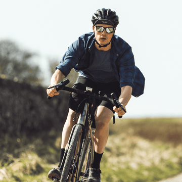
This story was sent to us by Sonder Customer Phil Thomas, a very happy owner of a Sonder Camino.
My alarm goes off at 5am. "Why the. Oh yeah!". Luckily my bags are packed from the night before, my kit is laid out, my chain oiled. All that's left to do is force a bagel down my neck and head out.
5 miles to the meeting point to start the ride. The roads are quiet so I start to think about what's to come. This route was put together by a friend of mine. They’re always tough. I'm getting used to them by now though, being told "just a short loop" and ending up trudging through a swamp with 60 miles till home.
This one is a bit different though. I've been warned. "Harder than last week's 200k, much harder. Just bring a lot of food, and a capable bike."
Better take the Camino then.

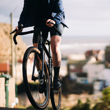
The route starts on familiar tracks, a very gradual climb that drops you off right on the doorstep of the North Pennines, getting rougher on the way and ending in a very steep, rocky descent. This section is about 30 miles long, 100% off road and has plenty of options at the top for various rides. I've been up here a lot.
After a water stop and bit of faffing with the map we get going again, now having to make up the route for a bit as the gps is taking us down a footpath. After jumping a few fences and gates, we're through the fields and back on a familiar road, but not for long.

I can see where we're heading. Harthope Moss. The highest paved pass in England. I've done it before. It's tough but manageable.
"Hey we missed the turn off! No?"
Turns out theres another way over the ridge. A bridleway to the west, completely unpaved with an even higher elevation. The surface is very rough but can be ridden all the way, on the right bike. This was probably the hardest climb I've ever done, but not the hardest climb of the day. I was warned!
The next 10 miles or so are a bit of a blur, I have no idea where we are but we're at 2000ft and still climbing. The scenery is incredible. No man made structures in sight, the yellow gravel road stretching out ahead as far as I could see, and barely a cloud in the sky. You don't get this on a road bike.

Eventually the track leads to Greg's Hut, a bothy just north of Cross Fell. We have to keep moving though, it's gone midday and we're a long way from home. After signing the guestbook and filling our bottles from a nearby stream, we get back to the climbing. It's a mostly ok surface with a few walking sections over the bigger rocks. Finally, the summit, 2500ft. We're rewarded with a panoramic view of the Lake District off in the distance. Best push on.
I'm not sure if we were following a bridleway or road here but whatever it was, it disappeared leaving just a very steep grassy expanse laid out before us. We had 2000ft of elevation to lose in 4 miles, this could be interesting. No path to speak of at all, we had to just judge it and pick out the best line down the mountain side, avoiding the huge rocks and craters. Finally the path takes shape again and then we're back on country roads for a short stretch.

It's time for lunch so we stop at the side of the road and have a fair bit to eat, almost everything I have. From here we can look back at the route down the mountain we'd just taken. I'd wanted to visit this area for a while but didn't expect to be here with my bike, let alone having ridden here from my front door. It wouldn't be the same if I'd driven half way or even got the train.
Turning off the quiet main road we stop at an information board. The map shows a bridleway right across to the road in the next valley. Perfect, though neither of us had been down it before.

"It must be rideable, right? And even if it's not, it's only 3 miles to the top, we can walk that easy. Lets have a look."
It was not rideable. It was barely walkable. We couldn't even push our bikes over the rocks so we had to carry them on our backs. Those three miles felt like 30. Out of food, out of water and the afternoon was starting to get really hot. The heat, the gradient, the terrain, I was completely exhausted. A few steps, rest, get on the bike for a few metres, fall off, a few more steps, rest. The only thing keeping us going was the ridiculous view to our right. High Cup Nick. An almost perfectly V-shaped valley carved into the rock by a glacier during the last ice age. I'd seen photos but you can only appreciate the scale of it in person.

We finally made it to the highest point. The terrain levelled out a bit and we were able to coast the short distance to the point at which the valley walls meet.
Time was flying by now but we had to stop for some photos. There were a few funny looks and comments from walkers, but we’d made it through.
“We are through aren’t we? Where’s the path?”
We’d been on this bridleway for hours now so I assumed we must have finished it. We were barely half way. Following a stream for a few miles meant it was at least fairly flat, but with no real path to speak of, it was hard slog to the road.

The road! The actual road we’ve been aiming for! I knew where we were now too. I knew there was a 10 mile descent into the next town where we could get something to eat, it still felt like a long way off but I’d make it.
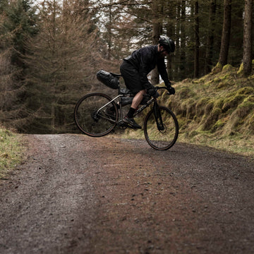
Two visits into the Co-op, bags and belly were full again, ready for the ride home. It’s amazing what a big pile of food can do for you, mentally and physically. It was starting to get dark so we got moving. The last challenge was an unknown climb up into Hamsterley forest that I'd known about for a while but never ridden. Hilariously exhausted, this section was just on the edge of what was rideable on a gravel bike and was a lot of fun. A gravel road that eventually turned to double track, thick gorse, deep puddles.

At the top it just kept getting better, an extremely fast gravel descent on fire roads through the forest. It was almost dark now and ahead of me, my friend’s bike was kicking up so much dust I couldn't see a thing. All I could do was follow the red flashing light in front and hope for the best. A surreal moment I won’t forget.
The rest of the ride wasn't exactly flat, none of County Durham is, but compared to what had come before it was a breeze.
123 miles over 15 hours 40 minutes. This is exactly what I got the Camino for.

If you've been out for a particularly memorable ride on a Sonder bike, long or short, then we'd love to hear it. Send your Sonder Stories to: stories@sonderbikes.com
Inspired? Take a look at the Sonder gravel range — aluminium, steel and titanium options, assembled to order in the UK.

Your next reads